


وصف لـ Mapit GIS - Map Data Collector & Land Surveys
Mapit is a professional, stand-alone, cost effective mapping and surveying tool designed to enhance productivity while you are out there in the field.
The app supports common file formats for input and output and is capable to work with number of external GNSS receivers so you can get a centimetre level accuracy when you need to.
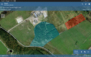
Design your survey forms, organize data on layers, work offline with mbtiles base-maps, access WMS services, use GPS tracking to capture your line and polygon features, record GNSS metadata and much more to discover.
The app is widely used by professionals around the world and can be easily adopted for different applications from agriculture and forestry to road construction, geology, land surveying and solar panel solutions. Personalized settings and flexibility makes this app fit for purpose tool which will enhance your surveying workflow.
App can be also used as a measurement tool to calculate areas or distances.
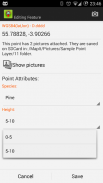
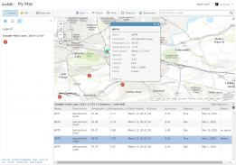
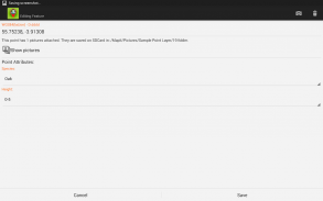
When saving location simply choose required attributes from predefined drop-down list, no need to type the same information over and over again. Import long list of attributes from text files and re-use them in number of projects. If necessary you can add pictures to each location as well.
If you are working in the field, gathering large amount of spatial data this app is designed for you.
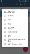
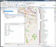
Speed up your workflow and make the data collection more efficient. Take advantage of survey layers and possibility to re-use same set of attributes for multiple surveys. Export your data to common GIS formats like Esri shapefiles, CSV, KML, geojson, DXF, GPX and post process your data using Desktop GIS software like qGIS.
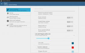
Support for number of predefined coordinate systems and customised EPSG codes if required.
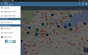
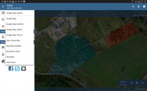
Mobile Data Collection Features:
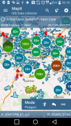
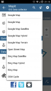
- Base maps: Popular online maps selections and offline mbtiles,
- Support for RTK corrected coordinates when external Bluetooth GPS / GNSS is connected,
- Support for WMS and GIS Server Tiled map services - load topographic and orthophoto maps, geological surveys, cadastral information and number of other services.
- Possibility to create and maintain sets of attributes - these are available as a drop down lists when new feature is being recorded, long lists of values can be imported from text files.
- Clusters for point map markers, efficient way of having large number of points on the map without performance issues,
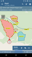
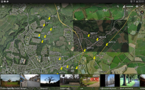
- Currently 4 methods of collection are supported (GPS / GNSS location, map cursor location, tracking, point projection using angle and distance),
- Possibility to group your data into the survey layers - each survey layer may have a default set of attributes.
- Local SD card or remote export. At the moment shapefiles, KML, CSV, geojson, GPX and DXF export is supported,
- Direct export to Dropbox or FTP location
- Possibility to record multiple points, lines and polygons on one layer,
- When creating new polygon or line features measurement details like area or length are also available.
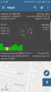
- GPS / GNSS and satellites status,
- Address, location search,
- Import point, line and polygon features into layer from CSV, KML, shapefile or geojson file,
- Backup management,
- Import/Export attributes from file and much more to discover...
Our users are successfully using Mapit in number of applications including:
- Environmental and woodland surveys,
- Forestry planning and woodland management,
- Agriculture and soil classifications and sampling,
- Road constructions,
- Land surveying,
- Solar panels applications,
- Roofing and fencing,
- Tree surveys,
- GPS and GNSS surveying,
- Site surveying
- Snow removal
Do not hesitate to contact us directly or using the contact form on our website.
Mapit هي أداة رسم الخرائط والمساحة احترافية وذات تكلفة منخفضة ومصممة لتعزيز الإنتاجية أثناء وجودك في هذا المجال.
يدعم التطبيق تنسيقات الملفات الشائعة للإدخال والإخراج وهو قادر على العمل مع عدد من مستقبلات GNSS الخارجية حتى تتمكن من الحصول على دقة مستوى السنتيمتر عندما تريد.
صمم نماذج الاستقصاء الخاصة بك ، وقم بتنظيم البيانات على الطبقات ، واصل العمل في وضع عدم الاتصال مع خرائط قاعدة mbtiles ، والوصول إلى خدمات WMS ، واستخدم تتبع نظام تحديد المواقع العالمي (GPS) لالتقاط ميزات الخط والمضلع ، وتسجيل بيانات GNSS الوصفية وغير ذلك الكثير لاكتشافها.
يستخدم التطبيق على نطاق واسع من قبل المتخصصين في جميع أنحاء العالم ويمكن اعتماده بسهولة لتطبيقات مختلفة من الزراعة والغابات إلى بناء الطرق والجيولوجيا ومسح الأراضي وحلول الألواح الشمسية. تجعل الإعدادات المخصصة والمرونة هذا التطبيق مناسبًا للأداة التي من شأنها تحسين سير العمل في المسح.
يمكن استخدام التطبيق أيضًا كأداة قياس لحساب المناطق أو المسافات.
عند حفظ الموقع ، اختر ببساطة السمات المطلوبة من القائمة المنسدلة المحددة مسبقًا ، لا حاجة لكتابة نفس المعلومات مرارًا وتكرارًا. استيراد قائمة طويلة من السمات من الملفات النصية وإعادة استخدامها في عدد من المشاريع. إذا لزم الأمر يمكنك إضافة الصور إلى كل موقع كذلك.
إذا كنت تعمل في هذا المجال ، فجمع كمية كبيرة من البيانات المكانية تم تصميم هذا التطبيق من أجلك.
تسريع سير العمل الخاص بك وجعل جمع البيانات أكثر كفاءة. استفد من طبقات الاستقصاء وإمكانية إعادة استخدام نفس مجموعة السمات في استطلاعات متعددة. قم بتصدير بياناتك إلى تنسيقات GIS الشائعة مثل ملفات الأشكال Esri و CSV و KML و geojson و DXF و GPX ثم قم بمعالجة بياناتك باستخدام برنامج Desktop GIS مثل qGIS.
دعم لعدد من أنظمة الإحداثيات المحددة سلفًا ورموز EPSG المخصصة إذا لزم الأمر.
ميزات جمع البيانات المتنقلة:
- الخرائط الأساسية: التحديدات الشائعة للخرائط عبر الإنترنت و mbtiles دون اتصال بالإنترنت ،
- دعم إحداثيات تصحيح RTK عند اتصال Bluetooth GPS / GNSS خارجي ،
- تقديم الدعم لخدمات الخرائط المتجانبة WMS و GIS Server - قم بتحميل الخرائط الطبوغرافية وتقويم العظام ، والمسوحات الجيولوجية ، والمعلومات المساحية وعدد الخدمات الأخرى.
- إمكانية إنشاء مجموعات من السمات والحفاظ عليها - تتوفر هذه كقوائم منسدلة عند تسجيل ميزة جديدة ، ويمكن استيراد قوائم طويلة من القيم من الملفات النصية.
- مجموعات علامات خريطة النقاط ، طريقة فعالة للحصول على عدد كبير من النقاط على الخريطة دون مشاكل في الأداء ،
- يتم حاليًا دعم 4 طرق للتجميع (موقع GPS / GNSS ، موقع مؤشر الخريطة ، التتبع ، إسقاط النقاط باستخدام الزاوية والمسافة) ،
- إمكانية تجميع البيانات الخاصة بك في طبقات الاستطلاع - قد يكون لكل طبقة استطلاع مجموعة افتراضية من السمات.
- بطاقة SD المحلية أو التصدير عن بعد. في الوقت الحالي ، يتم دعم تصدير ملفات KML و CSV و geojson و GPX و DXF ،
- تصدير مباشرة إلى موقع Dropbox أو FTP
- إمكانية تسجيل نقاط وخطوط ومضلعات متعددة على طبقة واحدة ،
- عند إنشاء مضلع جديد أو ميزات خطية ، تتوفر أيضًا تفاصيل القياس مثل المساحة أو الطول.
- حالة GPS / GNSS والأقمار الصناعية ،
- العنوان ، البحث عن الموقع ،
- استيراد ميزات نقطة وخط ومضلع في طبقة من ملف CSV أو KML أو ملف الأشكال أو geojson ،
- إدارة النسخ الاحتياطي ،
- استيراد / تصدير سمات من ملف وأكثر من ذلك بكثير لاكتشاف ...
يستخدم مستخدمونا بنجاح Mapit في عدد من التطبيقات بما في ذلك:
- المسوحات البيئية والغابات ،
- تخطيط الغابات وإدارة الغابات.
- تصنيفات الزراعة والتربة وأخذ العينات ،
- إنشاءات الطرق ،
- المسح الارضى،
- تطبيقات الألواح الشمسية ،
- التسقيف والمبارزة ،
- المسوحات شجرة ،
- مسح GPS و GNSS ،
- مسح الموقع
- إزالة الثلج
لا تتردد في الاتصال بنا مباشرة أو باستخدام نموذج الاتصال على موقعنا.
Mapit GIS - Map Data Collector & Land Surveys - إصدار 7.8.0.0Core
(16-08-2021)

Mapit GIS - Map Data Collector & Land Surveys - معلومات APK
نُسخة APK: 7.8.0.0Coreالحزمة: com.osedok.gisdatacollectorآخر إصدار من Mapit GIS - Map Data Collector & Land Surveys
تطبيقات من الفئة نفسها
قد يعجبك أيضًا...


